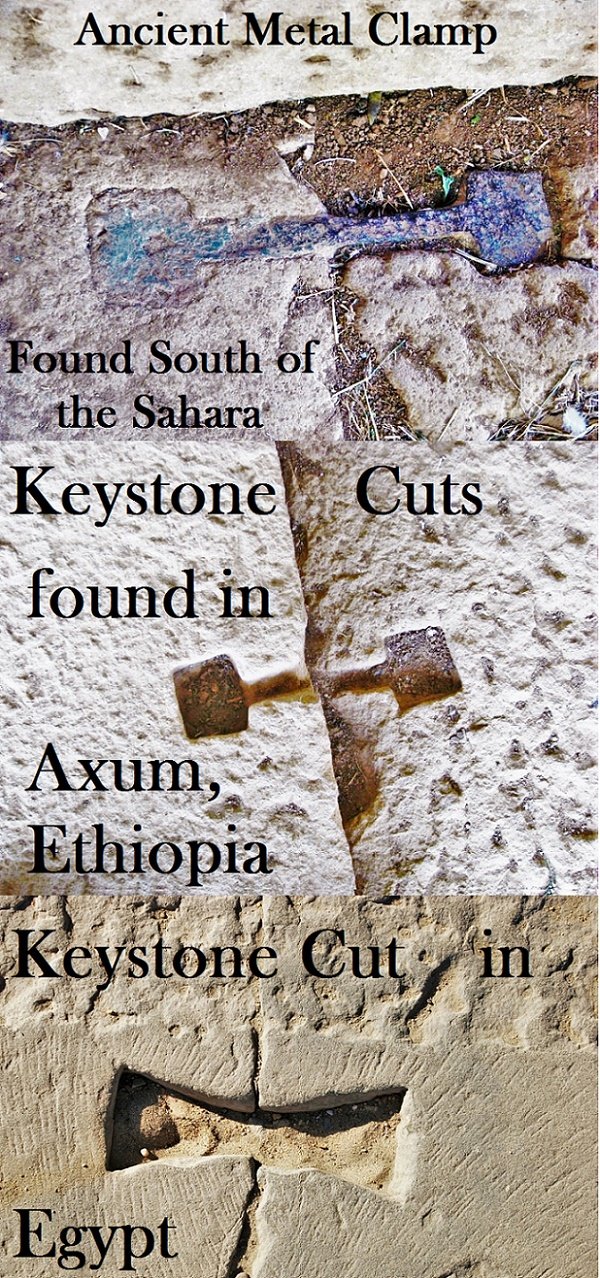
The keystone cuts were found near the tombs of King Remhai & King Kaleb?
Once carved, molten metal was poured into the joint to strengthen it and stop lateral movement of ancient megalithic stones.

I’m not sure as to why it seems like the general populous doesn’t know that Ethiopia has a 7,000+ year old history. I wouldn’t be surprise if Ethiopian history goes further back than that.
King Kaleb Of Axum

Kaleb (c. 520) is perhaps the best-documented, if not best-known, king of Axum situated in modern-day Eritrea and North Ethiopia.
Besides several inscriptions bearing his name, Axum also contains a pair of ruined structures, one said to be his tomb and its partner said to be the tomb of his son Gabra Masqal. (Tradition gives him a second son, Israel, whom it has been suggested is identical with the Axumite king Israel.) This structure was first examined as an archaeological subject by Henry Salt in the early 19th century; almost a century later, it was partially cleared and mapped out by the Deutsche Aksum-Expedition in 1906. The most recent excavation of this tomb was in 1973 by the British Institute in East Africa.
3rd-century Ethiopian King Remhai
(currently the Obelisk of Axum now stands)
The largest of Axum’s stelae, credited by tradition to the 3rd-century King Remhai, now lies shattered on the ground. Its collapse is linked by tradition to Queen Yodit, who destroyed many of Axum’s finest buildings, but scholarly opinion is that it toppled over either while it was being erected or soon afterwards, probably because the base of the stele was too small to support it. Remhai’s stele still lies where it fell. It weighs 500 tons and would be over 33m high were it standing. It is decorated with a door and 12 windows.
Not far from this stele, Remhai’s Tomb consists of 12 underground vaults that are high enough to walk through. The most striking thing about this tomb is the precision of its masonry, which consists of large blocks of granite held together by metal pins. In the back vault, Remhai’s sealed stone coffin lies where it was abandoned after Neville Chittick’s excavations were aborted following the 1974 revolution. Another nearby excavation that should not be missed is the Tomb of the Mausoleum. Opened to the public for the 2007 millennium celebration, this tomb has two entrances connected by a corridor. The entrance doors are rock-hewn and feature a common design with doors found at the churches of Tigrai. The west entrance door was damaged (along with many lintel beams) at the time the big stele collapsed, but the east door remains intact. Three ‘shaft tombs’ serve as skylights that illuminate the stack-stone constructed passage, and five burial chambers line each side.
Lost Cities & Ancient Mysteries of Africa & Arabia
Our current name for the Atlantic Ocean was previously called Oceanus Aethiopicus (Ocean Ethiopia) in the past.
1644 map
Blaeu, Willem Janszoon, 1571-1638.
“Africae nova descriptio.” Copperplate carte à figures map, with added color, 35 x 45 cm. From the second volume of Blaeu’s Le theatre dv monde; ov Novvel atlas contenant les chartes et descriptions de tous les païs de la terre (Amsterdam, 1644). Gift of J. Monroe Thorington, Class of 1915. [Rare Books Division]
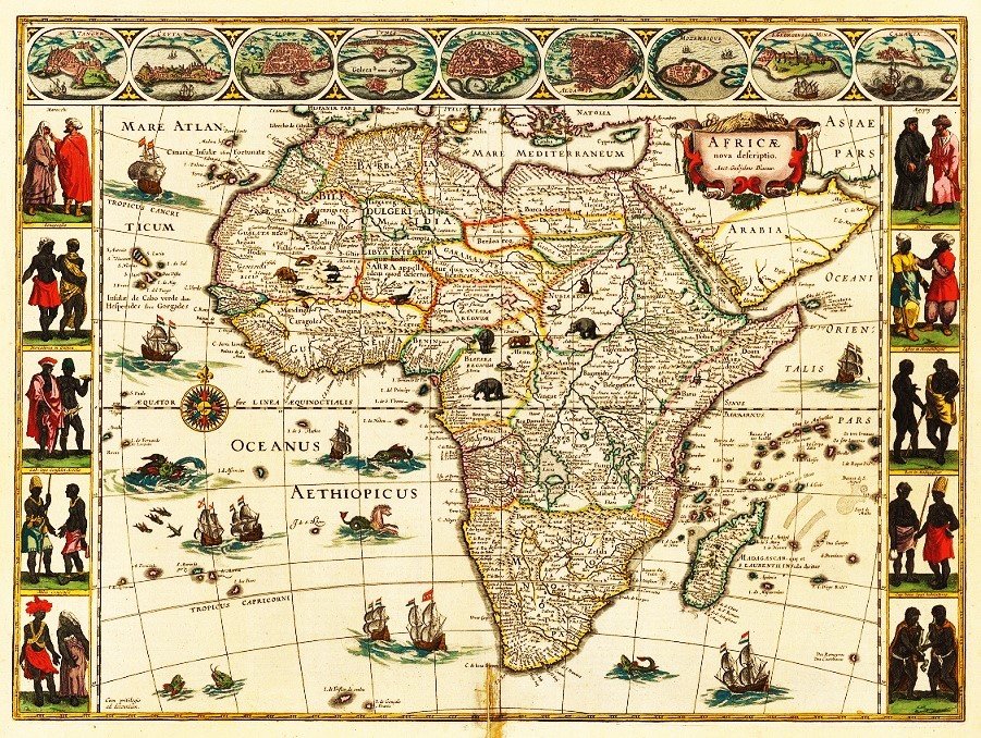

One of the most decorative and popular of all early maps of Africa, from the “golden age” of Dutch mapmaking. First issued in 1630, the map was reprinted many times between 1631 and 1667, appearing in Latin, French, German, Dutch, and Spanish editions of Blaeu’s atlases. The maps and atlases of the Blaeu family business, carried on after Willem’s death by sons Cornelis and Joan, marked the epitome of fine engraving and coloring, elaborate cartouches and pictorial detail, and fine calligraphy—the most magnificent work of its type ever produced.1644 map
Blaeu, Willem Janszoon, 1571-1638.
In the format called carte à figures, this appealing map contains oval views of, presumably, the major cities and trading ports of Africa at the time: Tangier and Ceuta (Morocco), Tunis (Tunisia), Alexandria and Cairo (Egypt), Mozambique (seaport of Mozambique), Elmina (Ghana, site of the largest and most spectacular castle in Africa built by the Portuguese), and Grand Canary (Canary Islands) Side panels depict costumed natives from areas visited along the coasts. The interior is decorated with exotic animals (lions, elephants, ostriches), which were (and still are) a major source of fascination for the public. The Nile (today’s White Nile) is shown flowing from the Ptolemaic lakes of Zaire and Zaflan. Flying fish and strange sea creatures cavort in the oceans, and the sailing ships all bear Dutch flags. Coastal names are engraved inward to give a clear, sharp outline to the continent.
Probably the most interesting cartographic feature is the identification of specific large territories or kingdoms, which have been outlined in color, including a huge Abyssinia (Ethiopia) and Monomotapa (all of southern Africa). But these seem to reflect a European sense of nationhood—something presumed and projected upon a virtually unexplored canvas—more than the actual experience of traders and explorers, who would continue to report on hundreds of smaller ethnic enclaves and political fiefdoms during the next 250 years.
1554 Map of Africa – Princeton University
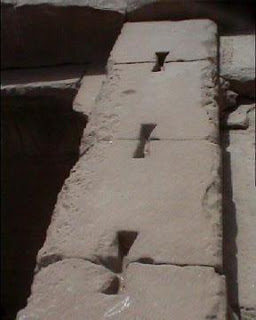
Another example of a keystone cuts in Egypt

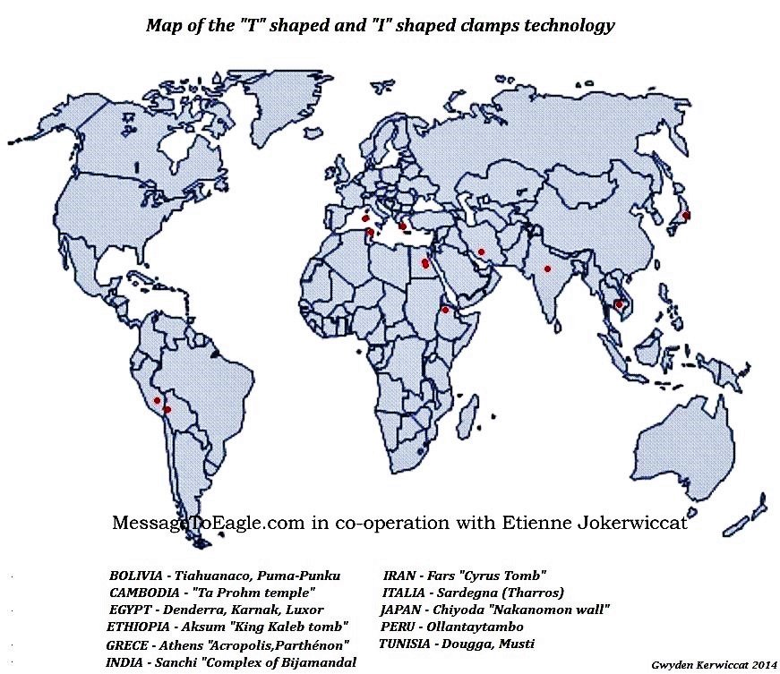
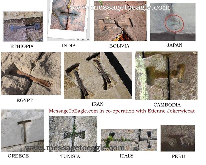
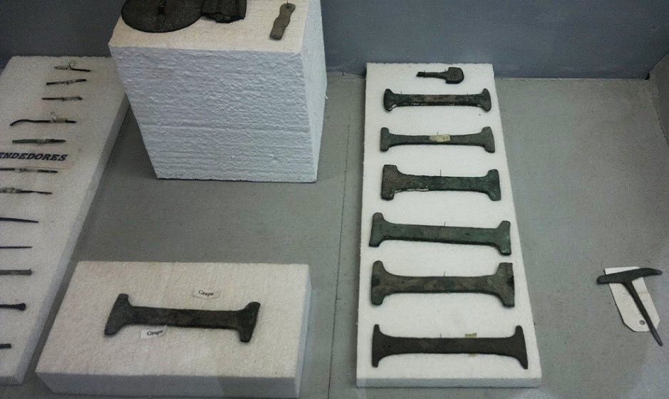
The most interesting fact is that these clamps were used all over the world. How did this technique and the knowledge find it’s way to Egypt, Pre-Columbian Peru and Cambodia, thousands of years and tens of thousands of miles apart? What is the common thread, or who was the common teacher?
Sources:
–ancientlosttreasures.yuku.com/topic/4611/Ancient-Clamps
–bradtguides.com/destinations/africa/ethiopia/axum
–Scientists May Have Figured Out How Ancient Egyptians Moved Huge …
Alternative Theories of our ancient past
Join Hugh Newman & Andrew Collins in Cambodia in March 2017: megalithomania.co.uk– Highlights of the 14 day tour include the Equinox Sunrise alignment, and the 20,000 year old Gunung Padang in Java?

Authors and explorers Hugh Newman and Andrew Collins investigate Angkor Wat in Cambodia searching for lost stone technologies and they question the strange keystone cuts that are also found in Peru, Egypt and other ancient temples around the world.
Explore with Megalithomania in 2016 on local tours to Stonehenge, Avebury and Glastonbury, plus further afield at Gobekli Tepe, Peru & Bolivia (with Jim Vieira), Egypt and Baalbek, Mexico, plus Angkor Wat and Gunung Padang: megalithomania.co.uk/tours
Filmed, Produced, and Directed by Hugh Newman. Copyright Hugh Newman 2015/2016. All Rights Reserved.


Vitrified Stone from Peru photos courtesy of Jan Peter de Jong.
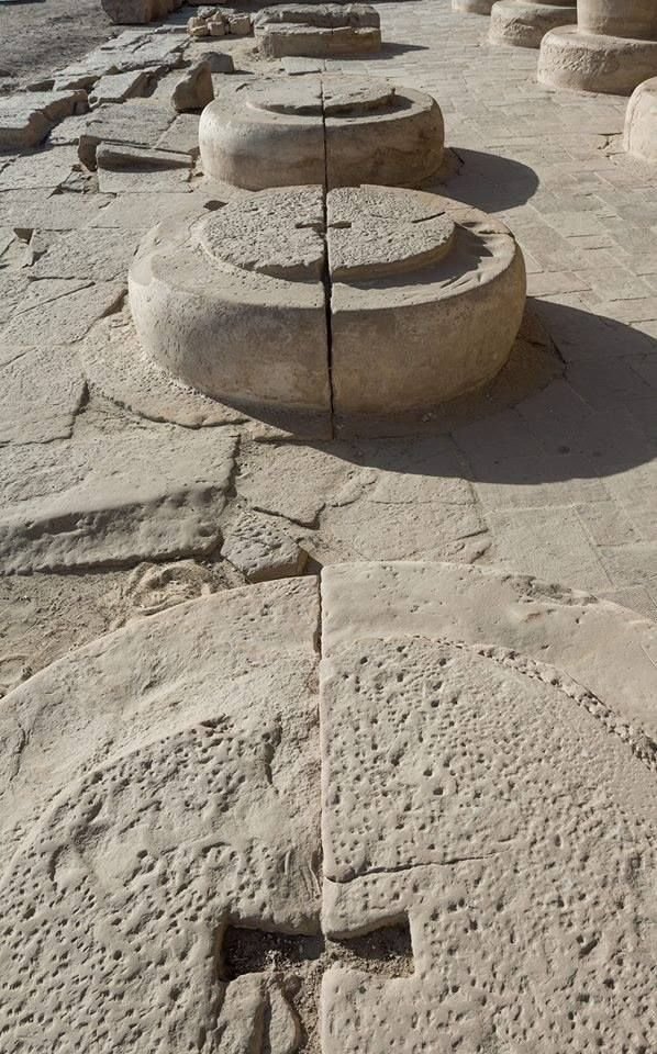

The ancient clamp technology, stone column bases.
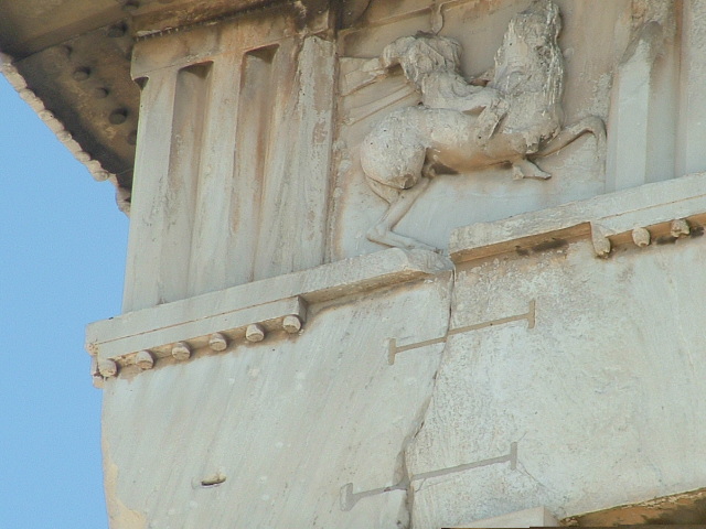
Key stone cuts in the Acropolis Parthenon Fragment
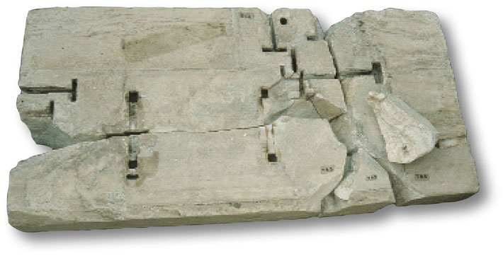

–archaeology.org/issues/193-1511/features/3771-athens-acropolis-parthenon
Another photo of the Acropolis keystone cuts, Greece

Keystone cut clamp with iron bar and lead, Persepolis, Iran
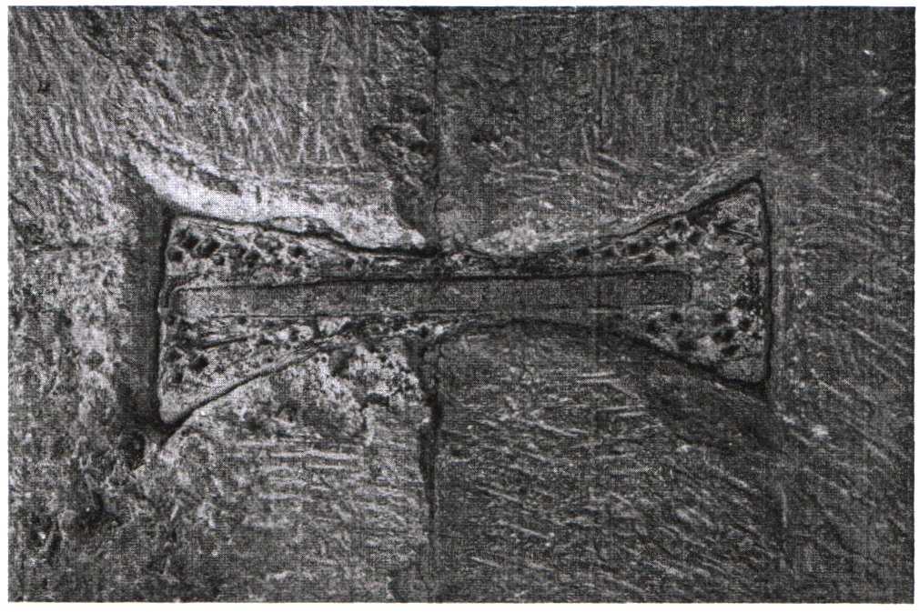

Broad dove-tail clamp with iron bar and lead, (Persepolis, Platform)
Tiauanaco silver metal clamps

–Lost Cities of Atlantis, Ancient Europe & the Mediterranean